Cork (Cork)
 |
 |
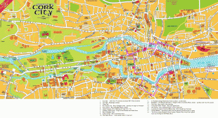
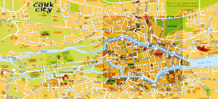
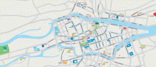
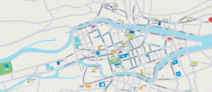
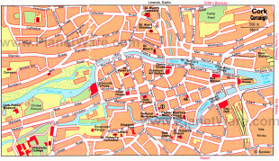
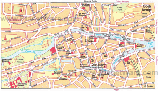
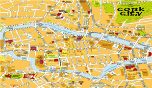
The city centre is an island positioned between two channels of the River Lee which meet downstream at the eastern end of the city centre, where the quays and docks along the river lead outwards towards Lough Mahon and Cork Harbour, one of the largest natural harbours in the world.
Originally a monastic settlement, Cork was expanded by Viking invaders around 915. Its charter was granted by Prince John in 1185. Cork city was once fully walled, and the remnants of the old medieval town centre can be found around South and North Main streets. The city's cognomen of "the rebel city" originates in its support for the Yorkist cause in the Wars of the Roses. Corkonians sometimes refer to the city as "the real capital", a reference to its opposition to the Anglo-Irish Treaty in the Irish Civil War.
Cork was originally a monastic settlement, reputedly founded by Saint Finbarr in the 6th century. Cork became (more) urbanised some point between 915 and 922 when Norseman (Viking) settlers founded a trading port. It has been proposed that, like Dublin, Cork was an important trading centre in the global Scandinavian trade network. The ecclesiastical settlement continued alongside the Viking longphort, with the two developing a type of symbiotic relationship; the Norsemen providing otherwise unobtainable trade goods for the monastery, and perhaps also military aid.
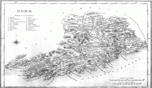
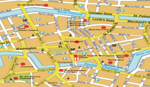
The city's charter was granted by Prince John, as Lord of Ireland, in 1185. The city was once fully walled, and some wall sections and gates remain today. For much of the Middle Ages, Cork city was an outpost of Old English culture in the midst of a predominantly hostile Gaelic countryside and cut off from the English government in the Pale around Dublin. Neighbouring Gaelic and Hiberno-Norman lords extorted "Black Rent" from the citizens to keep them from attacking the city. The present extent of the city has exceeded the medieval boundaries of the Barony of Cork City; it now takes in much of the neighbouring Barony of Cork. Together, these baronies are located between the Barony of Barrymore to the east, Muskerry East to the west and Kerrycurrihy to the south. The city's municipal government was dominated by about 12–15 merchant families, whose wealth came from overseas trade with continental Europe – in particular the export of wool and hides and the import of salt, iron and wine.
The medieval population of Cork was about 2,100 people. It suffered a severe blow in 1349 when almost half the townspeople died of plague when the Black Death arrived in the town. In 1491, Cork played a part in the English Wars of the Roses when Perkin Warbeck, a pretender to the English throne, landed in the city and tried to recruit support for a plot to overthrow Henry VII of England. The then-mayor of Cork and several important citizens went with Warbeck to England but when the rebellion collapsed they were all captured and executed.
The title of Mayor of Cork was established by royal charter in 1318, and the title was changed to Lord Mayor in 1900 following the knighthood of the incumbent mayor by Queen Victoria on her visit to the city.
Since the nineteenth century, Cork had been a strongly Irish nationalist city, with widespread support for Irish Home Rule, and the Irish Parliamentary Party, but from 1910 stood firmly behind William O'Brien's dissident All-for-Ireland Party. O'Brien published a third local newspaper, the Cork Free Press. Cork was overtaken by Belfast as Ireland's second-largest city in the nineteenth century.
In the War of Independence, the centre of Cork was burnt down by the British Black and Tans, in an event known as the "Burning of Cork" and saw fierce fighting between Irish guerrillas and UK forces. During the Irish Civil War, Cork was for a time held by anti-Treaty forces, until it was retaken by the pro-Treaty National Army in an attack from the sea.
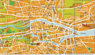
Map - Cork (Cork)
Map


Country - Ireland
 |
 |
| Flag of the Republic of Ireland | |
Geopolitically, Ireland is divided between the Republic of Ireland (officially named Ireland), an independent state covering five-sixths of the island, and Northern Ireland, which is part of the United Kingdom. As of 2022, the population of the entire island is just over 7 million, with 5.1 million living in the Republic of Ireland and 1.9 million in Northern Ireland, ranking it the second-most populous island in Europe after Great Britain.
Currency / Language
| ISO | Currency | Symbol | Significant figures |
|---|---|---|---|
| EUR | Euro | € | 2 |
| ISO | Language |
|---|---|
| EN | English language |
| GA | Irish language |